> ## Documentation Index
> Fetch the complete documentation index at: https://docs.agrihub360.com/llms.txt
> Use this file to discover all available pages before exploring further.
# Read the Grazing Wedge
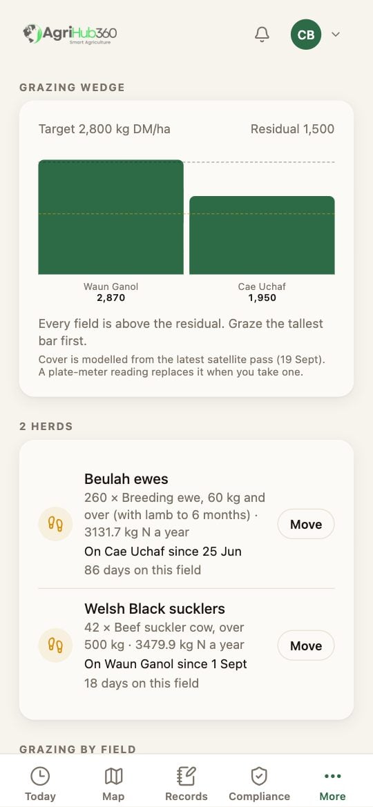
> Each field's grass cover as a bar, worked out from the satellite, with the target and the residual drawn across.
**Before you start.** The farm has a herd on a field. [Move a Herd](/how-do-i/map/move-a-herd) puts one there.
Above the herds is the **Grazing wedge**, one bar per field, tallest first. Cover is in kg of dry matter per hectare.
The dark dashed line is the pre-grazing **target**, 2,800 kg DM/ha. The amber one is the **residual**, 1,500, the cover to leave when the herd moves off. A bar under the residual goes amber.
Each herd's row shows days on its field. When its field is at the residual the row reads **Move soon** and the Move button goes solid.
 ## What You See Next
Graze the tallest bar first. The caption says where the cover came from, which is the latest satellite pass and its date. A plate-meter reading replaces it when you take one.
## If It Does Not
| You see | It means | Do |
| ----------------------------------- | ------------------------------------ | ------------------------------------------------------------------------------- |
| No wedge | No field has a satellite capture yet | The first capture arrives with the next clear pass, usually within a day or two |
| A bar is missing | That field had cloud on every pass | It fills in on the next clear one |
| The cover looks high for the season | NDVI reads canopy, not height | Take a plate-meter reading and record it |
Related: [Move a Herd](/how-do-i/map/move-a-herd), [Livestock and the Manure Plan](/features/farm-management/livestock-and-manure-plan).
## What You See Next
Graze the tallest bar first. The caption says where the cover came from, which is the latest satellite pass and its date. A plate-meter reading replaces it when you take one.
## If It Does Not
| You see | It means | Do |
| ----------------------------------- | ------------------------------------ | ------------------------------------------------------------------------------- |
| No wedge | No field has a satellite capture yet | The first capture arrives with the next clear pass, usually within a day or two |
| A bar is missing | That field had cloud on every pass | It fills in on the next clear one |
| The cover looks high for the season | NDVI reads canopy, not height | Take a plate-meter reading and record it |
Related: [Move a Herd](/how-do-i/map/move-a-herd), [Livestock and the Manure Plan](/features/farm-management/livestock-and-manure-plan).